


Tokyo's top day hikes
Get out and about on Tokyo's well-worn paths
Discover more of Japan with UnionPay

100 best shops in Tokyo

Most viewed
Most recent blogs

Style of the Day


Recent features / venues
Connect with us

Posted: Fri Sep 13 2013
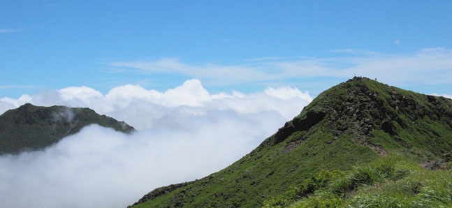
Instead of suffering in the crowded concrete of Tokyo, hit the dusty trails of the many mountainous regions that hug the prefecture's border. The following day hikes provide excellent vistas, close encounters with nature and a hefty dose of history, and – most importantly – you can be safely back in Tokyo in time for last orders…
Mount Takao
Ask a Tokyoite where to go hiking and they'll most likely direct you to Takao-san (599m), the Disney of Japan’s mountain treks, located just a 45-minute train ride from Shinjuku. Take the paved trail No 1 for a three-hour round trip past the Takaosan Yakuoin Yukiji Temple, monkey house and food vendors, or, if you fancy more of a challenge, take trail No 6 or the Inariyama Trail. Enjoy a view of Mount Fuji at the summit, before hurtling back down to the popular beer garden.
Transport: Takaosanguchi Station (Keio Takao line)
Mount Tsukuba
At the centre of Ibaraki, Mount Tsukuba (877m) is shrouded in myth. An hour and a half north of Akihabara, Tsukuba-san is one of the ‘100 Famous Japanese Mountains’. Its two peaks house the deities Izanagi-no-Mikoto and Izanami-no-Mikoto and the route features several rock formations. Follow one of two courses: the winding 2.6km Shirakumobashi course or the steep 2.4 km Miyukigahara course. The round trip is three hours (or take the cable car and grab a beer at the top).
Transport: Tsukuba Station (Tsukuba Express) then change bus to Tsukuba-san Shrine
Mount Hodo
This secret trail is located next to the beautiful city of Nagatora in Saitama. The cable car to the summit is a 15-minute walk from the station. Opened in 1961, the lift cabins are the oldest still in use in Kanto. The trail up the stumpy Hodo-san (497m) is relatively easy compared with most hikes. At the top, hikers are rewarded with views of the neighbouring mountains and the river valley below, as well as a small zoo and plum garden.
Transport: Kumagaya Station (JR Takasaki line) then Nagatoro Station (Chichibu line)
Mount Mitake
The shrine at the summit of Mount Mitake (929m), located west of Tokyo, is believed to have been a centre of worship for more than 2,000 years. Less than two hours away, intrepid hikers can climb the 'trail' (a paved road) from the station, or take the funicular to the summit and explore by foot from there. The aforementioned Musashi-Mitake Shrine, and the trails from the Mitake summit lead to a rock garden, waterfalls and the peak of Mount Otake (1,267m).
Transport: Mitake Station (Ome line)
Mount Koubou
This is a family-friendly hike just outside of Hadano near Kanagawa, an hour southwest of Shinjuku. The beginning of the two and a half hour climb, setting off from Hadano, is a tad steep, but it eases into a rolling trail that follows a ridge to the summit of Koubou-san (235m), and the descent to the Tsurumakionsen finish is quite gentle. On clear days there is a splendid view of Mount Fuji, and also Sagami Bay. The trail is particularly popular during sakura season.
Transport: Hadano Station (Odakyu Odawara line)
Otama Trail
An hour and a half from Shinjuku, the Otama Trail is in the furthest western regions of Tokyo Prefecture. This gentle 8km trek starts at Kori Station in the east and winds its way along the Tamagawa on well-built trails, rural roadsides and suspension bridges, ending two and a half hours later at Okutama Station. While the trail is far from rugged, it does provide close-up interaction with nature and a gorgeous view of the Hatonosu Valley.
Transport: Kori or Okutama Station (Ome line)
Mount Oyama
Known as Kunimi-yama (Guardian of the Land), Mount Oyama (1,252m) has been a favourite among pilgrims for over 250 years. Take the cable car to Oyama Afuri Shrine or choose between the ‘women’s’ and ‘men’s’ trails (the men’s trail is steeper). The trail to the summit starts from the left of the shrine and takes two hours (total round trip of 4-5 hours sans cable car). While descending the Kaminarinomineone trail, hikers have a panoramic view of the Tanzawa-Oyama National Park.
Transport: Isehara Station (Odakyu Odawara line) then bus #4.
Kamakura Alps
With very little altitude change and plenty of Genji history to take in along the way, hiking the Kamakura Alps is fun for all ages. The most common route is the Ten-en hiking course, starting at Kenchoji Temple and leading to Mount Ohira (159m). There are several offshoots to shrines and temples, and you'll spot ancient images of Buddha carved into the cliffs. On clear days you can catch glimpses of Mount Fuji, and the summit provides a view of Yuigahama and Sagami Bay.
Transport: Kita-Kamakura Station (Shonan-Shinjuku line)
Tags:
Related articles


Tweets
- About Us |
- Work for Time Out |
- Send us info |
- Advertising |
- Mobile edition |
- Terms & Conditions |
- Privacy policy |
- Contact Us
Copyright © 2014 Time Out Tokyo
Add your comment